Ramona Falls – Portland, Oregon
Driving To Ramona Falls
One of my favorite things in nature has always been waterfalls. With that being said, the first place I went after landing in Portland, Oregon was Ramona Falls. As we turned off the main road towards the trailhead, we lost internet connection. Luckily, we had taken some screenshots of the driving directions as well as the walking directions. We have Verizon Wireless, so another service might have stronger service in the area. I highly recommend taking some screenshots or writing down the directions ahead of time.
Parking at the trailhead requires either a Northwest Forest Pass or the purchase of a $5 day pass. I read somewhere that these can be purchased at the trailhead. However, when we got to the trailhead, the information board stated they needed to be purchased in the nearby town of Zigzag. We went ahead and risked it since it was almost the end of the season and we were running out of daylight. If you don’t feel like risking it, I would get a pass in the town ahead of time.
Walking To Ramona Falls
Distance: 7.0 miles round trip
Elevation gain: 1100 feet
Difficulty: Moderate

The low river and fallen trees made it relatively easy to cross.
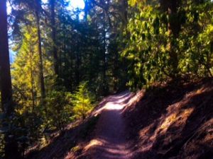
The River Side Ramona Falls Trail contains some small pathways with a steep drop off.
We followed the directions we found on the Oregon Hikers website and took the River Side Trail when it junctions with the Creek Side Trail at about 1.5 miles. As the name suggest, this trail goes along the Sandy River and it often sounds like you are approaching the waterfall before you actually are. After going up some elevation you run into some rather small pathways with a steep drop off on one side. Walking past other travelers on this path can be difficult and I found it best to step off to the side to let them pass. The picture to the right does not capture how steep the drop off is. At 2.8 miles you run into the PCT, just stay left on the Ramona Falls Trail and you’ll get to the waterfall at 3.3 miles.
Ramona Falls
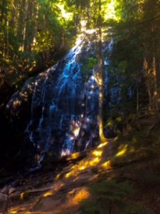
Ramona Fall is beautiful and definitely worth the hike.
When you are ready to leave you can either go down the way you came or take the Creekside Ramona Falls Trail that you saw earlier. While this option is .3 miles longer I highly recommend it. I personally like the change of scenery and the path is the shadier option on a sunny day. As with any hike through the woods, make sure to read the signs carefully to make sure you are heading the right way. This path intersects with many others and you can get turned around easily.
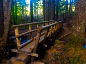
They’ve made some really cool log bridges to cross the Creekside Ramona Falls Trail.
Walking along the creek for the first mile was extremely beautiful and peaceful. To the right there is a large white rock wall that looks amazing between the creek and trees. You cross over the creek a couple of times and they have made some bridges out of logs that I think look really cool. You reconnect with the Riverside Trail at about 2.2 miles from the waterfall, take a right and go down the way you came. Cross over the river again and then 1 more mile until the trailhead.
Conclusion
This hike is rated at a moderate difficulty although I didn’t find it too difficult. It is no longer rated as family friendly since the bridge crossing the river has washed away. When we went, the river was low and the fallen trees made it easy enough to cross such that I would think a kid that has done a hike before should be fine. With more shade and no steep drop offs, the Creekside Trail seemed to be the easier route.
Like this article? Let me know in the comments below! Be sure to follow my social media accounts and sign up for my newsletter to stay up to date on my adventures!
0 Comments